Toggle navigation
- Home
- South Carolina Waterfalls
- Blue Hole Falls
- Upper Brasstown Falls
- Brasstown Falls
- Brasstown Cascade
- Brasstown Sluice
- Bull Sluice
- Cedar Creek Falls
- Cedar Falls
- Chauga Narrows
- Cheohee Road Falls
- Clearwater Falls
- Crane Falls
- Fall Creek Falls
- Upper Fall Creek Falls
- Falls Creek Falls
- Gauley Falls
- Isaqueena Falls
- Jones Gap Falls
- King Creek Falls
- Lower Lick Log Falls
- Upper Lick Log Falls
- Little Brasstown Falls
- Lohrs Falls
- Long Creek Falls
- Long Shoals
- Lower Whitewater Falls
- Opossum Creek Falls
- Pigpen Falls
- Rainbow Falls
- Ramsey Creek Falls
- Raven Cliff Falls
- Reedy Branch Falls
- Reedy River Falls
- Lower Reedy River Falls
- Secret Falls
- Sids Falls
- Spoonauger Falls
- Tunnel Falls
- Twin Falls
- Wildcat Falls
- Upper Wildcat Falls
- Yellow Branch Falls
- Georgia Waterfalls
- Ada-Hi Falls
- Ammons Falls
- Angel Falls
- Bad Branch Falls
- Becky Branch Falls
- Caledonia Cascade
- Chattooga River Rapids
- Crow Creek Falls
- Falls on Crow Creek Road
- Dicks Creek Falls
- Estatoah Falls
- Henderson Falls
- Holcomb Creek Falls
- Hurricane Falls
- Waterfall on Joe Branch
- L'Eau d'Or Falls
- Martin Creek Falls
- Minnehaha Falls
- Oceana Falls
- Panther Falls
- Stonewall Falls
- Sylvan Falls
- Tempesta Falls
- Tiger Creek Falls
- Toccoa Falls
- Falls at Warwoman Dell
- North Carolina Waterfalls
- Alarka Falls
- Anvil Horn
- Upper Waterfall on Auger Fork Creek
- Waterfall on Auger Fork Creek
- Lower Waterfall on Avery Creek
- Bard Falls
- Waterfall on Barnett Branch Trail
- Batson Creek Falls
- Middle Batson Creek Falls
- Upper Batson Creek Falls
- Bearwallow Falls
- Big Bradley Falls
- Big Falls
- Bird Rock Falls
- Cascades near Bird Rock Falls
- Bridal Veil Falls
- Bridal Veil Falls (Dupont)
- Upper Bridal Veil Falls (Dupont)
- Lower Waterfall on Bubbling Spring Branch
- Upper Waterfall on Bubbling Spring Branch
- Bubbling Spring Branch Cascade
- Buttermilk Falls
- Waterfall on Camp Branch
- Waterfall on Camp Creek
- Lower Waterfall on Caney Bottom Creek
- Upper Waterfall on Caney Bottom Creek
- Catawba Falls
- Catheys Creek Falls
- Cedar Rock Falls
- Waterfall on Charley Creek
- Chestnut Falls
- Chub Line Falls
- Connestee Falls
- Corn Mill Shoals
- Courthouse Falls
- Upper Courthouse Falls
- Waterfall on Courthouse Creek
- Cove Creek Falls
- Cove Creek Sliding Rock
- Crabtree Falls
- Cullasaja Falls
- D.E.W. Falls
- Diamond Creek Falls
- Dill Falls
- Upper Dill Falls
- Drift Falls
- Dry Falls
- East Fork Falls
- Unnamed Falls on the East Fork
- Eastatoe Falls
- Elk Falls
- Waterfall on F.R. 475
- Glenn Falls
- Glen Burney Falls
- Glen Cannon Falls
- Glen Marie Falls
- Waterfall on New Years Creek
- Waterfall on Gold Creek
- Lower Waterfall on Gragg Prong
- Upper Waterfall on Gragg Prong
- Waterfall on Grassy Creek
- Grassy Creek Falls (Dupont)
- Grassy Creek Falls (Little Switzerland)
- Waterfall on Grogan Creek
- Harper Creek Falls
- Waterfall on Hickory Branch
- Hickory Nut Falls
- Hidden Falls
- High Falls (Dupont)
- High Falls (Thompson River)
- Hooker Falls
- Hunt-Fish Falls
- Indian Creek Falls
- Juney Whank Falls
- Johns Jump
- Key Falls
- Waterfall on Lamance Creek
- Laughing Falls
- Waterfall on Laurel Fork'
- Waterfall on Tributary of Laurel Fork
- Linville Falls
- Little Deep Ford Falls
- Waterfall on Little Long Creek
- Upper Waterfall on Little Lost Cove Creek
- Lower Waterfall on Little Lost Cove Creek
- Waterfall on Log Hollow Branch
- Waterfall on Northern Tributary of Log Hollow Branch
- Waterfall on Southern Tributary of Log Hollow Branch
- Waterfall on Long Branch
- Looking Glass Falls
- Lower Cascades
- Lower Falls
- Maidenhair Falls
- Waterfall on Maple Spring Branch
- McCall Mill Shoals
- Meece Shoals
- Merry Falls
- Middle Falls
- Mill Shoals
- Mingo Falls
- Moore Cove Falls
- Waterfall West of More Cove Falls
- Narrows Falls
- North Harper Creek Falls
- Pacolet Falls
- Pearson Falls
- Waterfall on Phillips Branch
- Waterfall on West Fork Pigeon River
- Rainbow Falls (Horsepasture River)
- Ranger Falls
- Raven Rock Falls
- Waterfall on Right Fork
- Rock Creek Falls
- Waterfall on Rockhouse Creek
- Rock House Falls
- Rufus Morgan Falls
- Lower Waterfall on Sams Branch
- Second Falls
- Shoal Creek Falls
- Waterfall on Shoal Creek
- Silvervale Falls
- Skinny Dip Falls
- Waterfall on Slate Rock Creek
- Slick Rock Falls
- Sliding Rock
- Slippery Witch Falls
- Soco Falls
- Upper Waterfall on Sols Creek
- South Harper Creek Falls
- Stairway Falls
- Waterfall on Steels Creek
- Step-Around Falls
- Still House Falls
- Stone Mountain Falls
- Ten-Foot Falls
- First Waterfall on Thompson River
- Second Waterfall on Thompson River
- Waterfall on Thorps Creek
- Tom Branch Falls
- Toms Creek Falls
- Waterfall on Toms Spring Branch
- Toms Spring Falls
- Torys Falls
- Toxaway Falls
- Trickle Falls
- Triple Falls
- Turley Falls
- Turtleback Falls
- Twin Falls (Henry Branch)
- Twin Falls (Thompson River)
- Quarry Falls
- Upper Buck Creek Falls
- Upper Cascades
- Upper Catawba Falls
- Upper Creek Falls
- Upper Falls
- Whitewater Falls
- Widows Creek Falls
- Wildcat Falls (Tributary of West Fork Pigeon River)
- Window Falls
- White Owl Falls
- Wintergreen Falls
- Yellowstone Falls
.
NORTH CAROLINA WATERFALLS
RANGER FALLS (3)
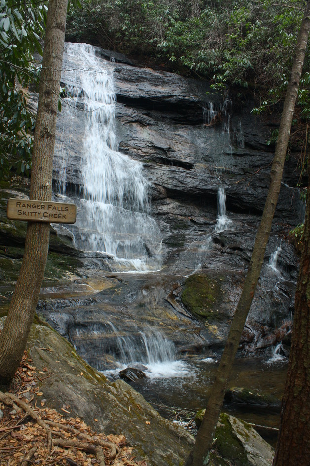
Driving Directions: From the intersection of U.S. 64 and N.C. 28 in Highlands, drive west on U.S. 64 for 4.4 miles to the Cliffside Recreation Area (F.R. 57) on the right. Turn into the Cliffside Recreation Area and drive 1 mile to a gate (which is closed in winter) and a fork in the road. If the gate is open, bear left and drive 0.35 mile to the picnic parking area.
Hiking Directions: At the parking area a sign stands for the trailhead to Ranger Falls. Walk on the trail for 0.26 mile to another trail on the left at another sign for Ranger Falls. Turn left and continue 0.73 mile to the base of the falls.
Hiking Directions: At the parking area a sign stands for the trailhead to Ranger Falls. Walk on the trail for 0.26 mile to another trail on the left at another sign for Ranger Falls. Turn left and continue 0.73 mile to the base of the falls.